|
|
|
|
|
|
|
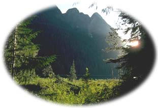 Strathcona Provincial Park is the oldest park on Vancouver Island and a wild treasure for many Islanders. At 231,434 ha (571,880 acres) this rugged mountain wilderness presides over the heart of the island. Strathcona Provincial Park is the oldest park on Vancouver Island and a wild treasure for many Islanders. At 231,434 ha (571,880 acres) this rugged mountain wilderness presides over the heart of the island.
This central jewel of Vancouver Island holds some of the last remaining rainforests on an island that has been ravaged by logging. Laced with lakes and rivers, it also contains unusual limestone formations that feature caves and sinkholes, and one of the tallest waterfalls in the world. Sometimes called "Little Switzerland" the park contains 6 of the 7 highest peaks on the island, as well as Comox Glacier, Vancouver Island's last remaining icefield.
|
"This larger more expanded protected area will hopefully provide the range and diversity of habitat the wildlife need in order to continue to evolve and adapt."
|

Strathcona Park is located in the center of Vancouver Island, west of Courtenay, and southwest of Campbell River. Buttle Lake and Forbidden Plateau are the areas of most interest for day use. To get to the Buttle Lake area of the park, take Highway 28 from Campbell River, which passes through the northern section of the park before branching off. The southern branch provides access to Buttle Lake and the park's headquarters. Two areas, Paradise Meadows (Mount Washington) and Forbidden Plateau (Wood Mountain), provide easy access to the high country. To reach these entrances follow Highway 19 north from Comox or south from Campbell River, and then follow the signs.
|
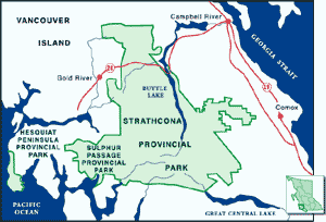
Click on the map to view an enlargement
|

Strathcona contains prime examples of ancient rainforests of Douglas-fir, western red cedar, grand and amabilis fir, and western hemlock. At higher elevations sub-alpine fir, and mountain hemlock are found. The wildlife here have evolved a little differently from their mainland relatives, and many, including the Vancouver Island marmot, Vancouver Island wolf, Roosevelt elk, and black-tailed deer, are unique to Vancouver Island.
Strathcona's abundant birdlife includes red-breasted nuthatch, kinglet, Stellar's jay, and band-tailed pigeon, chestnut-backed chickadee, winter wren, ruffed grouse, and blue grouse. The park is also home to a small number of unique Vancouver Island white-tailed ptarmigans. The connection of Strathcona Park with the newly formed Clayoquot Biosphere Reserve area is based on the Conservation Biology principle of connectivity. This larger protected area will hopefully provide the range and diversity of habitat that wildlife needs in order to continue to evolve, adapt, and thrive.
|
"The wildlife here have evolved a little differently from their mainland relatives, and many, including the Vancouver Island marmot, Vancouver Island wolf, Roosevelt elk, and black-tailed deer, are unique to Vancouver Island."
|

Although there are a few developed facilities in the park, most of Strathcona is remote wilderness. Situated conveniently close to urban centers, it is a popular playground for islanders as well as visitors fom afar. From seaside to snowcapped mountains, Strathcona offers a wide variety of outdoor experiences for all ages, including canoeing, kayaking, windsurfing, camping, hiking, mountain climbing, swimming, and skiing. A park interpreter is available during July and August. 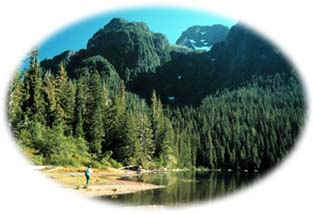
AccommodationStrathcona has two campgrounds: Buttle Lake with 85 campsites and Ralph River with 76 sites. Both these sites are located at Buttle Lake and can be accessed by Hwy 28. The campsites have firewood, water, and toilets. There are also some marine backcountry sites on Rainbow Island and the western shores of Buttle Lake. Instead of camping, many visitors choose to stay at Strathcona Park Lodge, situated on the shores of Upper Campbell Lake, and just outside the park's eastern boundary.
HikingStrathcona has 104 km (65 mi) of trails leading to sites throughout the park and showing off its most scenic features. These trails in the park will satisfy a range of hikers from the experienced backcountry enthusiasts to families with young children. Many local outdoor clubs also offer excellent trips. All trails in Strathcona Provincial Park are closed to mountain bikes and horses, and pets are to be kept out of backcountry areas because of potential wildlife conflicts.
For more detailed information on specific trails in the park click here.
|
"There are trails in the park to satisfy all people, from the experienced backcountry enthusiasts to families with young children."
|
Mountain Climbing
Rock climbing is a popular activity in the park. Mountaineers will find a variety of peaks for all levels including the highest peak on Vancouver Island, the 2200 m (7219 ft) Golden Hinde. The Crest Creek Crags area has over 100 climbing routes.
Water SportsButtle Lake, 32 km (20 mi) long, is the main waterway in the park, and has two boat launches. Strathcona has several other tranquil lakes and rivers on which to enjoy canoeing, kayaking, or swimming. Angling for Dolly Varden, cutthroat and rainbow trout is often excellent in any of the lakes.
Winter ActivitiesStrathcona's heavy snowfall and superb views make it a winter paradise. The Forbidden Plateau/Mount Washington area is considered to be the number one alpine and nordic skiing destination on Vancouver Island. Over 30 km (19 mi) of groomed trails provide stunning views of glaciers and mountain peaks, rolling farmland, and dense forests as far as the Strait of Georgia.
|

Established in 1911, Strathcona was the first provincial park created in BC. Now dear to the hearts of many islanders, Strathcona is still the largest park on the island. The park was named after Donald Alexander Smith, First Baron Strathcona and Mount Royal, a Canadian pioneer and of the major backers of the Canadian Pacific Railway. It was he who drove the last spike into the rail line that linked the young nation of Canada from sea to sea.
Strathcona seemed remote in the early days, but after WWII when vehicles first made long distances accessible, Strathcona began to attract public attention. At one time the government hoped that Strathcona would become as popular as Banff National Park. That never materialized and thankfully much of Strathcona still remains wild.
Unfortunately in the 1960s the government approved a proposal to build a mine in the park. Buttle Lake, in the center of the park, was dammed to create energy to power the mine, and a highway was built right through the heartland. This was met by great resentment and bitterness from the public and was one of the factors that led to the beginning of BC's wilderness movement. In the late 1980s when the mining company wanted to expand its operations, and explore further claims in the park, public outcry and blockades resulted in those claims eventually being retired.
The highly viable logging threats that currently face Strathcona Park along its perimeter are but another chapter in the story of the struggle to avoid destruction in this wilderness by the modern world. Hopefully citizen involvement and activism will ensure that this potential disaster will be avoided.
Following the completion of the Clayoquot Sound Land-Use Decision discussions in 1995, the Megin-Talbot addition was added to Strathcona Provincial Park. This 27,390 hectares (26,877 ha upland, 513 ha foreshore) addition includes the entire watersheds of both the Megin and Talbot Rivers, and links the interior portion of Strathcona Park to the Clayoquot Sound region of the west coast of Vancouver Island.
The Megin watershed is especially significant, as it is the largest remaining undisturbed watershed on Vancouver Island. The Megin-Talbot area contains interesting karst limestone topography (which features caves), numerous rare plants as well as notable old-growth spruce, fir and cedar forests.
Other, smaller additions have also resulted from the Vancouver Island Land-Use Planning Process, including the Divers Lake Addition (1,034 ha/2,550 acre) and the McBride Creek Addition (3,750 ha/9,300 acre).
|
Return to the Vancouver Island Region
Become Involved!
|
|