|
|
|
|
|
|
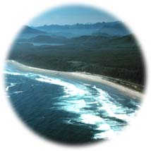 Located in Clayoquot Sound on the west coast of Vancouver Island, Pacific Rim National Park has some of the most beautiful and easily accessible Pacific Ocean beaches in Canada.
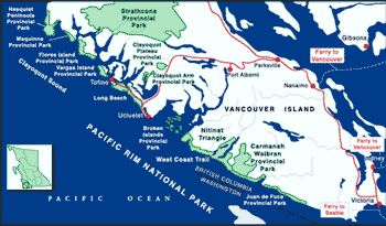
The unique coastal park is composed of three parts: Long Beach, the West Coast Trail (which includes the Nitinat Triangle), and the Broken Island Group.
Visitors come to experience the roar of the Pacific surf on its sandy beaches, explore the lush coastal rainforest, kayak in the island archipelago, or just relax and watch the mists of morning give way to spectacular sunsets.
|
"The [West Coast] trail winds along the rugged shoreline, offering glimpses of secluded sandy beaches which spread out from rocky headlands."
|

Long Beach
To get to the Long Beach section of the park, located between Ucluelet and Tofino, take Highway 4 west from Port Alberni for about 108 km (65 mi). The winding road takes about 90 minutes to reach the Ucluelet-Tofino junction, where visitors should turn right. The Long Beach unit of the park is just a few more minutes further down the road.
West Coast Trail and Nitinat Triangle
The West Coast Trail is a world-renowned 75 km (47 mi) long coastal hiking trail, stretching from Port Renfrew to Bamfield, on the west coast of Vancouver Island.
Nitinat Triangle features three low elevation lakes and extensive old growth rainforest. To get there, turn off Highway 1 north of Duncan and follow either the north or south shore of Lake Cowichan. Follow the Nitinat Main logging road to the head of Nitinat Lake.
|
Click on the map to view an enlargement
|
Broken Group Islands
Boats or kayaks can access the Broken Group Islands from Toquart Bay. Visitors must travel 12 km (7.4 mi) NE from the junction of Highway 4 and the Tofino-Ucluelet Highway, before turning onto the unsigned road which leads to the bay.
Alternatively, several boats including the Alberni Marine Transport Ltd. vessels, the M.V. Lady Rose, and the M.V. Frances Barkely travel between Port Alberni, the Broken Group Islands, Ucluelet, and Bamfield. They will transport paddlers and kayaks/canoes into the Broken Group Islands.
|

Pacific Rim National Park is home to an extensive variety of wildlife both in the sea and on the land. Within the park's rainforests blacktail deer, cougar, marten, mink, Vancouver Island wolf, black bear, raccoon, and many more wild creatures thrive.
At the shoreline visitors are often thrilled by views of various marine animals such as seals, porpoises, 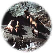 sea lions, and several species of whales that frequent the area. The most commonly seen of these are the California sea lions, Steller's (Northern) sea lions, and harbour seals. Sea Lion Rocks, just offshore from Comber's Beach in Long Beach provides an excellent opportunity to see these large (but smelly) creatures. Less frequently seen are Northern fur seals and Northern elephant seals. sea lions, and several species of whales that frequent the area. The most commonly seen of these are the California sea lions, Steller's (Northern) sea lions, and harbour seals. Sea Lion Rocks, just offshore from Comber's Beach in Long Beach provides an excellent opportunity to see these large (but smelly) creatures. Less frequently seen are Northern fur seals and Northern elephant seals.
Visitors from all over the world flock to the villages of Tofino and Ucluelet to see the Gray whale migration from mid-March to mid-April. Virtually annihilated by commercial whalers during the early 1900s. The Pacific herd has now increased to more than 20,000 individuals, after gaining international protection in 1947. Every spring, gray whales move through these waters on their annual migration from Baja California and Mexico to the Bering Sea.
Birdwatching is another popular activity in Pacific Rim Park, as the park contains feeding grounds for many shorebirds, as well as bald eagles. Birdwatchers have counted a total of 249 species ranging from albatrosses to waxwings in the park 54 of these species breed in the area.
|
"Every spring, over 20,000 gray whales move through these waters on their annual migration from Baja California and Mexico to the Bering Sea."
|

Long Beach
This portion of the park includes the most developed facilities, including the most popular local campsite, Green Point -located about 20km south of Tofino (note that in the summer there is often a one or two-day waiting list to get in) - and the Wickaninnish Information Center. The Wickaninnish Center is an interpretive center with numerous exhibits, displays and activities designed to help visitors understand the rainforest and marine ecology of the park. 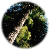
There are 9 walking trails within the Long Beach Unit of Pacific Rim National Park Reserve. Most of the trail routes have a boardwalk, wood chip, or gravel surface, and each offers walkers a different coastal experience.
Favorite activities include walking the sandy beaches, exploring the local tidepools, or scanning the horizon for passing whales, porpoises or seals. Swimming in the Pacific Ocean is a great way to cool down in the summer months. A surf guard is employed from June to September at Incinerator Rock, a popular surfing location off Long Beach.
The extensive marine life, breathtaking coastal views, and the longest sandy beach in BC make this portion of the park a unique and memorable one.
|
"Favorite activities include walking the sandy beaches, exploring the local tidepools, or scanning the horizon for passing whales, porpoises or seals."
|
The West Coast Trail
The West Coast Trail of Pacific Rim National Park is the most famous hiking trail in British Columbia. Located in the southern portion of the park, 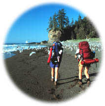 it winds along the coast southeast of Barkley Sound between the villages of Bamfield and Port Renfrew. The 75 kilometer (46 mile) trail was originally constructed for the rescue of shipwrecked mariners. Hikers must be experienced, fit, self-sufficient, and prepared for all types of weather to attempt this trail. it winds along the coast southeast of Barkley Sound between the villages of Bamfield and Port Renfrew. The 75 kilometer (46 mile) trail was originally constructed for the rescue of shipwrecked mariners. Hikers must be experienced, fit, self-sufficient, and prepared for all types of weather to attempt this trail.
The trail goes right into the heart of the temperate coastal rainforest. Dominated by old growth spruce, hemlock and cedar, it contains some of the taller and larger trees found in Canada. Winding along the rugged shoreline, the trail offers glimpses of secluded sandy beaches spreading out from rocky headlands.
It is incredibly beautiful, and also incredibly popular. To deal with the demand to hike the trail Parks Canada has set up a reservation system. Click here for information on reservations and how to visit the trail.
|
Nitinat Triangle
Located in the southernmost area of Pacific Rim National Park, Nitinat Triangle is one of the best wilderness canoeing areas in southwestern BC. Surrounded by towering old-growth red cedar and hemlock giants, some over 1,000 years old, Nitinat is a little known treasure.
Three lakes, Hobiton, Squalicum, and Tsusiat, make up the Nitinat Triangle; the main attraction of the Triangle is a beautiful 38 km (24 mi), 4-5 day, canoe journey, travelling from one serene, tree-lined lake to another.
For a beautiful description of this area see: Centuries In The Life Of A Great Cedar - Nitinat Triangle.
|
Broken Group Islands
Approximately 100 small islands situated in beautiful Barkley Sound make up the Broken Group Islands of Pacific Rim National Park Reserve.  Although the outer islands are fully exposed to the force of the Pacific Ocean, the inner ones are ideal for canoeing, kayaking, and snorkeling. This part of the park encompasses an area of approximately 130 sq km (52 sq mi). Although the outer islands are fully exposed to the force of the Pacific Ocean, the inner ones are ideal for canoeing, kayaking, and snorkeling. This part of the park encompasses an area of approximately 130 sq km (52 sq mi).
Spending time in the Broken Islands is a magical experience. Divers of all ability levels come to explore the old shipwrecks, the rich marine life, and hundreds of tidal pools. Anglers come fishing for spring salmon, coho, and cod. The waters surrounding the islands teem with marine life ranging from tiny plankton to giant whales.
There are eight designated camping areas in the Broken Group, and all island visitors must camp in these sites. Because this area is so popular visitation limits have been set. The maximum stay on each island campsite is 4 days. Maximum group size is 10, and maximum stay in the Broken Group Islands overall is 14 days. Boaters should bring an adequate drinking water supply with them. Solar composting outhouses are provided at all eight campsites.
|
"Spending time in the Broken Islands is a magical experience."
|

The West Coast Trail was started in 1907, after the sinking of the steamship Valencia in 1906 killed 126 passengers and crew. The trail was built to provide a telegraph line and cabins for survivors of shipwrecks. Rough weather along the rugged coastline has caused more than 60 ships to go down in this "Graveyard of the Pacific." The lifesaving trail roughly followed the old telegraph route and connected the lighthouses at Cape Beale and Carmanah Point with other lighthouses and towns on southwest Vancouver Island. As years passed, with modern navigation and communication, the trail became obsolete, and was allowed to become overgrown by the lush rainforest. However, by 1973, with renewed interest from recreationists Parks Canada began to reconstruct the trail for backpacking, completing it by 1980.
For many years Vancouver Islanders had proposed that a park be created along the west coast of Vancouver Island to include the coastline near Tofino and the historic life-saving trail. In the 1960s a campsite park was established at Long Beach and people flocked there, often camping and squatting on the beach. In the late 1960s it was a focal point for hippie backpackers who made their way across the country and ended up on Long Beach.
The love affair the public had with this area encouraged the Federal Parks Minister at the time, Jean Chretien, to protect the area as Pacific Rim National Park. The park was made up of three units: the Long Beach section of surf beaches, the Broken Group Islands Archipelago, and the strip of land running 80 km (50 mi) along the West Coast Trail from Bamfield to Port Renfrew. Pacific Rim National Park Reserve was dedicated in 1970 by Princess Anne.
Then in the early 1970s, the first citizen led effort to save wilderness in Canada focused on the Nitinat Lakes country. The campaign aimed to protect some of the area's exceptional old growth forest and was led by a group of university students including Ric Careless of BC Spaces For Nature. The citizens were successful in stopping the logging proposals and having Nitinat Triangle preserved, in 1971. In the mid 1980s the Nitinat Triangle was formerly added to Pacific Rim National Park, bringing the park to its current size.
|
"...visitors come to experience the roar of the Pacific surf on its sandy beaches, explore the lush coastal rainforest, kayak in the island archipelago, or just relax and watch the mists of morning give way to spectacular sunsets."
|
Return to the Vancouver Island Region
Become Involved!
|
|
|