|
|
|
|
|
|
|
 Naikoon Provincial Park offers visitors a chance to experience the British Columbia coast in the wild form few people have had the opportunity see. Vast sandy beaches stretch for nearly 100 km (62 mi) along the north and east boundaries of the park, creating a beach lover's paradise. Located in the far northeast corner of the Queen Charlotte Islands, 72, 640 hectare (179, 500 acre) Naikoon Provincial Park is far from the more densely populated areas of southern BC. Visitors will have the opportunity to experience true wilderness solitude while exploring the misty, and at times wet and windy, shores of Graham Island. Naikoon Provincial Park offers visitors a chance to experience the British Columbia coast in the wild form few people have had the opportunity see. Vast sandy beaches stretch for nearly 100 km (62 mi) along the north and east boundaries of the park, creating a beach lover's paradise. Located in the far northeast corner of the Queen Charlotte Islands, 72, 640 hectare (179, 500 acre) Naikoon Provincial Park is far from the more densely populated areas of southern BC. Visitors will have the opportunity to experience true wilderness solitude while exploring the misty, and at times wet and windy, shores of Graham Island.
Naikoon is a mostly flat park, punctuated by a few glacial and volcanic features reaching heights of up to 150 meters (492 ft) in the case of the park's highest point, Argonaut Hill. The nature of the park is characteristic of its location in the Hecate Depression, a trough that has formed between the Coast Mountains to the east and the Outer Mountains to the west.
Visitors to Naikoon Provincial Park will no doubt enjoy its wild and seemingly endless beaches and the experience of time spent along stretches of British Columbia's least populated coastlines.
"Visitors will have the opportunity to experience true wilderness solitude while exploring the misty, and at times wet and windy, shores of Graham Island."
|

Naikoon Provincial Park is located in the northeast corner of Graham Island, the most northerly of the Queen Charlotte Islands (a chain of islands located off British Columbia's mid-coast). A BC Ferries route, which operates between Prince Rupert on the Mainland and Skidegate on the Graham Island, provides access to the Queen Charlotte Islands. Travellers must reserve ahead for this 6-8 hour crossing.
Alternatively, visitors can reach Skidegate by scheduled flights from Vancouver or Prince Rupert.
From Skidegate, visitors can reach Naikoon by travelling north along Highway 16. The highway skirts the south and west boundaries of the park, with access provided at Mayer Lake, Tlell, and northeast of the small community of Masset onto Great North Beach. The park itself is undeveloped and there is no internal access, except on foot. The headquarters of the park are found just south of the bridge over the Tlell River, some 40 km (25 mi) north of Skidegate.
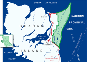
Click on the map to view an enlargement
|
|
"Visitors to Naikoon Provincial Park will no doubt enjoy its wild and seemingly endless beaches and the experience of time spent along stretches of British Columbia's least populated coastlines."
|

Naikoon is true wilderness. It contains no facilities and the nearby communities are too small to be counted upon for sufficient accommodation or supplies, and thus visitors should arrive in Naikoon self-sufficient and prepared for wilderness living. Visitors to Naikoon Park should also be aware that while the coastal climate of the area is generally mild year round, it is also an exposed area prone to mist, as well as plenty of rain and wind. Such weather is characteristic of most of the British Columbia coastline and should be seen as a part of the appeal. Visitors equipped with a full compliment of warm clothes and wet weather gear will enjoy Naikoon no matter what weather they face.
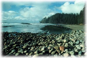
The park's biggest attraction is no doubt its extensive beaches. Visitors to Naikoon can spend countless hours combing the shoreline that creates both the north and east boundaries of the park. There are several trails in Naikoon, which wind through the coastal forests and lead along the extensive beaches.
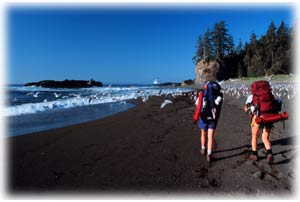 Visitors can enjoy hikes ranging in length from hour-long loops, to full day hikes and all the way to more extensive multi-day excursions. Before setting off it is important that hikers are aware of the tides, since beach access at some places can be completely cut off at higher tides. The main trails start at the Tlell River day use site (at the south end of Naikoon) or in the day-use parking lot at Tow Hill (on the northwest of the park). In addition, the freshwater ponds and lakes of Naikoon Park provide opportunities for beautiful day use paddling. Visitors can enjoy hikes ranging in length from hour-long loops, to full day hikes and all the way to more extensive multi-day excursions. Before setting off it is important that hikers are aware of the tides, since beach access at some places can be completely cut off at higher tides. The main trails start at the Tlell River day use site (at the south end of Naikoon) or in the day-use parking lot at Tow Hill (on the northwest of the park). In addition, the freshwater ponds and lakes of Naikoon Park provide opportunities for beautiful day use paddling.
Backcountry camping is permitted throughout the park, and established campsites are located at Agate Beach in the north east corner of the park and Misty Meadows in the southwest. Walk-in or canoe/kayak accessible tent-only campsites are available along East Beach, near Rose Spit and at Mayer Lake. There are no facilities at the backcountry locations, but the established campsites offer pit toilets, tent pads, and water taps. There are also group campsites available at the Misty Meadows Campground, in the southeast corner of Naikoon.
Mayer Lake offers day use canoeing or kayaking, as well as a primitive boat launch for car top boats. Excellent fishing can be found at Mayer Lake, as well as Tlell River, which is well known for its salmon runs. Anglers are reminded that a valid fishing licence is required in British Columbia.
|
|
"Visitors to Naikoon can spend countless hours combing the shoreline that creates both the north and east boundaries of the park."
|

The Queen Charlotte Islands are located between 55 and 120 km (35-75 mi) from the mainland, meaning that it is not easy for animals to make the crossing. Furthermore, these offshore islands escaped the full force of the last ice age, allowing evolution to continue unhampered. Consequently, many species on the islands continue to evolve and live fairly isolated from their counterparts on the mainland, giving the Queen Charlottes the nickname of the "Galapagos of the North". As a result, there are several unique species or sub-species to be found in Naikoon Park. At least 39 endemic species, including seven mammals, three birds and fifteen species of the stickleback fish, have been found to exist on the Queen Charlottes and no where else in the world.
Also due to this isolated evolution, the Black bears found on the Queen Charlotte Islands are larger than any others in North America, and have exceedingly strong jaws with which they can crush open shells. River otter and marten are also relatively common in the park.
The ocean waters that create the north and east borders of Naikoon are home to sea mammals such as Pacific White-sided dolphins and Dall's porpoises. Hair seals are commonly seen from the park's beaches year round. During May and June it is possible to see California grey whales and Northern fur seals as they migrate north for the summer.
For the most part the bird species composition in the park is the same as on the mainland, but there are a few notable exceptions. The Queen Charlotte Islands are home to unique sub-species of hairy woodpeckers, saw-whet owls and Steller's Jays. The Queen Charlottes and Vancouver Island are home to a sub-species of pine grosbeak, and one sub-species of song sparrow is found only in the Queen Charlottes and on some islands in Alaska. The park, especially Rose Spit, is a key stop over point for migrating waterfowl and shorebirds travelling the Pacific Flyway, and is thus an excellent area for bird watching. The beaches of Naikoon are home to numerous resident shore bird species, and the park is also a gathering location for sandhill cranes. Upwelling currents around the Rose Spit area bring food to the surface, attracting sea birds normally not seen from shore.
Also present in the park are numerous species that have been introduced from the mainland. Sitka Blacktail deer were first brought to the Queen Charlottes some 80 years ago, and have flourish due to an abundance of available food and lack of predators. Raccoons, red squirrels, beaver, and muskrat are other introduced species that may be seen in Naikoon. There are some small herds of wild cattle in the area as well, a result of historic settlement attempts.
"The waters that create the north and east borders of Naikoon are home to sea mammals such as Pacific White-sided dolphins and Dall's porpoises."
|

Naikoon's earliest human history begins with its use and importance to the Haida First Nations. The Haida and their ancestors had lived in these islands for many thousands of years. During this time they developed an especially thriving and advanced culture. Even the park's name has its root in this history; in the language of the Haida people the distinctive point of land now known as "Rose Spit" was once called "Nai-kun", which meant "long-nose".
In July 1774 the Haida Gwaii/Queen Charlotte Island's history changed dramatically, when explorer Juan Perez first spotted them. Perez had been commissioned to explore the coast by the Spanish Viceroy of California. A few years later, in 1787, British explorer Captain George Dixon named the islands after his ship, the Queen Charlotte.
By the early 1900s the provincial government was actively encouraging settlers to the islands. Many of these settlers chose the area that is now Naikoon Park for their homesteads. They attempted to farm and raise cattle on the low-lying land and mine for gold on the sandy beaches. Unfortunately for them, the area's lack of access and poor drainage combined with the lack of markets and hardship created by World War One meant that the area was mostly abandoned by the time the depression hit in the 1930s.
The conservation history of Naikoon Provincial Park begins in 1973, when it was among a suite of parks created by the NDP government in an attempt to make up for the dismantling of Hamber Park. The former Social Credit government had diminished the park system by 740,000 hectares (1,828,614 acres) when they took apart Hamber Provincial Park in order to allow for damming of the Columbia River.
Naikoon, along with other parks (such as Carp Lake and Atlin was created as a way to make up for this loss. The intention in protecting Naikoon was to retain a sizeable area on the Haida Gwaii/Queen Charlotte Islands, and in fact this was the first serious conservation effort to focus on the Queen Charlottes. In particular, Naikoon was created to protect the stunning beaches along the north coast and down the east side of the park.
Where these beaches converge they form Rose Spit, a long narrow spit which extends out several kilometers to the north east and is an internationally important stopping area for migratory birds. The beaches of Naikoon are backed by low-lying, boggy forest that, while it does not have high forest values, is ecologically interesting due to its unique assemblage of endemic species.
"...Naikoon was created to protect the stunning beaches along the north coast and down the east side of the park."
|
|
Return to the Rainforest Coast Region
Become Involved!

|
|