|
|
|
|
|
|
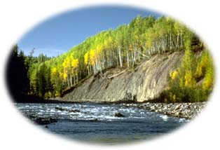
The Gitnadoix River Park (pronounced git-nah-doyks) is an excellent example of an undisturbed coastal watershed. Located in the Kitimat Mountain Range, this 58,000 hectare (14,3324 acre) park stretches from valley bottom to ridge top, incorporating all the ecosystems in between. Reminiscent of California's Yosemite Valley, the domed granite peaks that mark the edge of the watershed have been glaciated, forming massive steep cliffs and a U-shaped valley floor. From these cliffs many waterfalls cascade down towards the river; from one point it is possible to see 25 separate falls. The Gitnadoix River is a key tributary of the Skeena River, which flows into the Pacific Ocean.
|

Located about 80 km (50 mi) east of Prince Rupert, this is a challenging area to visit. As there are no roads the only access is by either by boat across the Skeena River or floatplane into Alastair Lake.
Click on the map to view an enlargement
|
|
"Reminiscent of California's Yosemite Valley, the domed granite peaks that mark the edge of the watershed have been glaciated, forming steep cliffs and a U-shaped valley bottom."
|

 With all 5 species of Pacific salmon, as well as rainbow and cutthroat trout, Dolly Varden char, and mountain whitefish found in its waters Gitnadoix River Park's chief recreational draw is its fishing. Fishers are reminded that in order to fish in BC they will need a valid fishing licence. With all 5 species of Pacific salmon, as well as rainbow and cutthroat trout, Dolly Varden char, and mountain whitefish found in its waters Gitnadoix River Park's chief recreational draw is its fishing. Fishers are reminded that in order to fish in BC they will need a valid fishing licence.
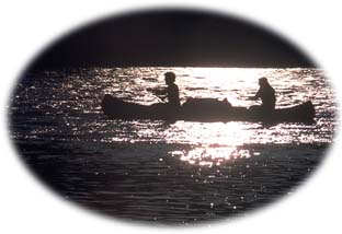
In addition to fishing opportunities the park is also a great place for boating, kayaking or canoeing. The Gitnadoix River is calm and meandering in its upper sections, but the lower portions contain some navigable class two and three whitewater, perfect for adventurous canoeists or kayakers. Visitors may backcountry camp in the park, but no facilities are provided. The weather in the northern coastal mountains of BC can be wet year round, and visitors should be prepared for this.
|
|
"The Gitnadoix River is calm and meandering in its upper sections, but the lower portions contain some navigable class two and three whitewater perfect for adventurous canoeist or kayakers."
|

Since the Gitnadoix Park area contains a variety of ecosystems, ranging from the river bottoms to the mountaintops of the Kitimat Range, it is home to a diversity of species. Water is an important feature of this park, in both rivers and wetlands, as it provides habitat for animals such as otter, moose, and beaver as well as many species of fish. The fish are in turn important for sustaining larger animals such as grizzly bears. Other large mammals in the area are black bears, wolves, and mountain goat. The area is also important because it is one of the 3 known nesting locations in BC for Trumpeter Swans.
The altitudinal range found in the park means that there is also a diversity of plant species and climate types. The Gitnadoix River Park supports three of BC's 14 biogeoclimatic zones: Coastal Western Hemlock in the valley bottoms, Mountain Hemlock on higher slopes, and Arctic Tundra in the highest and most exposed locations.
"Water is an important feature of this park, in both rivers and wetlands, as it provides habitat for animals such as otter, moose, and beaver as well as many species of fish."
|

The Gitnadoix River area has long been known for its significant recreational and environmental features. It was first identified in 1972 by the BC Wildlife Federation, in particular Ed Mankelow, as a candidate for protection as a wild river. (At the time the BC Wildlife Federation had a concept of rivers protection that provided a provincial-wide system of river protection that encompassed three categories: Wild River, Scenic Rivers, and Recreational Rivers.) Their initial and priority candidate for Wild Rivers status - ones that were truly natural - was the Gitnadoix.
While the Wild River concept was never realised it did succeed in alerting the public that the Gitnadoix was a valuable area for protected status. Subsequently ongoing pressure from the Wildlife Federation led to the area being designated as a Recreation Area (no logging been permitted, but mining allowed) in 1986. Then in 2001, as a result of the Kalum Land and Resource Management Plan process, Gitnadoix's protection status was elevated to full Class A park status, making it unavailable to mining. Also as a result of that LRMP the Giltoyees-Foch area, which directly adjoined Gitnadoix to the south, was also protected, effectively doubling the amount of wilderness protected in this region of the Kitimat Range.
"The Gitnadoix River area has long been known for its significant recreational and environmental features."
|
|
Return to the Rainforest Coast Region
Become Involved!

|
|